
Night Hikes/Paranormal Investigations
Waiver Forms. Information about the Hikes. What to Expect.
About the Night Hike/Paranormal Investigation
About the Hike/What to Expect
Night hike at Moonville Tunnel with the local ghost stories passed down, followed by a ghost hunt at the famous and haunted tunnel.
Night hikes and ghost hunts last approximately 2.5 hours. We will walk a gravel, out-and-back section of the Moonville Rail Trail, starting from the town of Moonville and heading to Ingham Station/Bear Hollow. I stop several times to tell the ghost stories passed along by the Moonville residents. They stories last about one to two minutes.
The hike is free of charge (I do accept tips) and covers a little over 1.5 miles one way, totaling 3.0 miles along an easy, flat gravel railroad bed. At a leisurely pace, it takes about 30-40 minutes to hike one way. However, we will be moving steadily and making a few short stops to hear local ghost stories, which may make it challenging for those with health issues, walking difficulties, or those who are not in good shape.
Signing Up/Registration
EVERYONE, INCLUDING CHILDREN, MUST HAVE A SIGNED WAIVER TO ATTEND! There are no exceptions.
You can see a copy of the waiver here. I will bring waivers to sign at the parking lot.
After, I’ll bring some ghost-hunting equipment so you can try a little ghost-hunting in the tunnel. And if you wish to download some of the online “ghost hunting” apps like Ghost Tube, we can test to see if they mirror some of the tried-and-true tools used over time.
Please check Jannette’s Facebook page listed below before coming for weather/flooding/cancellation or other updates.
I will have some of my Ohio, West Virginia, and Appalachian hikes books available (including the Moonville books, Haunted Hocking Hills, and the Vinton County haunts) for purchase for ten dollars a piece, but bring cash. There are no ATMs and the cell phone services are sketchy.
Under 18 must have a parent/guardian along for the hike and ghost hunt. (Parent/Legal Guardian of hikers under 18 must sign the waiver! A responsible adult/parent/guardian must hike with underage children).
How Do I SIGN UP?
Reservations are not required, but contacting me lets me know how many will attend as there is limited parking:
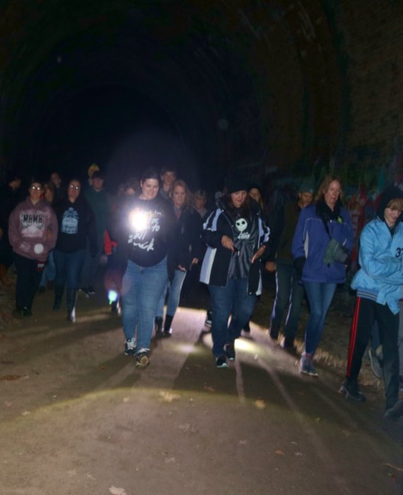
Here is what you might expect at a night hike/ghost hunt. Watch while visitors use the equipment to explore the tunnel and its ghosts!
Preparing for the Hike
Please take note of the following information:
- It will be dark on the return trip. No pets are allowed.
- You may bring a flashlight or use your cell phone for light.
- I recommend bringing bottled water/a container of water to drink.
- The area is surrounded by swamps, so it’s advisable to use insect repellent and wear light, loose-fitting long pants, and long-sleeve shirts during the spring and summer months.
- Children must remain with parent or guardian. There are areas on the trail that may pass cliff areas and waterways. You are responsible for yourself and your children.
- No climbing above the tunnel. There is nothing up there.
- This trail is also used by horse riders that do not remove the manure nor stay to the side of the trail as directed on most hor trails. It is not maintained for manure removal, so please wear appropriate shoes or boots. It can accumulate excessively.
- There are no restrooms available on-site. The closest facilities are a few miles away at Lake Hope State Park, just past the beach parking lot.
- I share ghost stories and folklore passed down by locals from he areas where they occurred. Children are welcome, but please keep in mind that ghost stories can be scary. You know your children best.
GPS for Moonville: 39.308451, -82.324552
Directions to Moonville (Noted in DARK BLUE):
From Oh-278, turn on to Wheelabout Road (you will see the Lake Hope State Park dam across from the road).
Go straight (left) on to Shea Road. (If you go past the Hope Schoolhouse, you took the wrong road). Follow the road that turns into gravel for 2.5 miles (there are no other roads) and you will cross a steel bridge and not far after, you will see a Moonville Rail Trail sign on the right.
The parking is on the left.
Directions to Moonville: Flood Route (Light Blue):
From Oh-278, turn on to Wheelabout Road (you will see the Lake Hope State Park dam across from the road).
*The road makes a Y at about .2 miles, make a right to continue on Wheelabout. (Straight is the way that is sometimes flooded)
You will pass the old Hope Schoolhouse.
*After two miles, you will see a little Y where the road jogs to the left or continues rounding to the right. Take this left. It will go from asphalt to gravel.
*There will be a stop sign at Hope Moonville Road. Make a left.
The parking lot will be on the right, watch for the rail-trail sign
If you use your cellphone for directions to the hike, once you are at Moonville, you may not be able to get service until you are about 20-30 minutes from the tunnel. That said, you may have trouble setting up your return home from the parking lot after the hike, so make sure you plan your route as a round trip.